The Falls Trail at Bandelier National Monument in northwest New Mexico is a 3 mile round trip to a waterfall in the lower section of Frijoles Canyon. The trailhead is at the Visitor Center area. The Falls Trail focuses on the natural environment, particularly water, and doesn’t visit any of the archaeological sites for which Bandelier is famous.

Before the 2012 season, the Falls Trail was a 5 mile round trip to two waterfalls, but the summer 2011 Las Conchas forest fire and later flash flood on August 21, 2011 washed out the lower segment of trail.
There is a printed trail guide for the Falls Trail available at the Visitor Center for $1.50. The 2012 end of the trail is at stop No. 16. There are also interpretive signs at the trailhead providing information.

The pinkish cliffs along the canyon are volcanic tuff. Between 1.6 and 1.2 million years ago there were very large volcanic explosions in the nearby Jemez Mountains that deposited thick layers of ash that later compacted to form the tuff. Running water erodes the soft rock quickly, forming steep walled canyons. At stop No. 5 there are some eroded tuff boulders called tent rocks. The trail guide provides an explanation for how tent rocks form.

This is a good view of Upper Bandelier Tuff layer from 1.2 million years ago at stop No. 7. The Upper Bandelier Tuff is widely visible around the area and is associated with the Valles Caldera volcanic area a short distance west of the Bandelier Park area. This layer is described as being deposited by pyroclastic flow.
The Frijoles Creek is a permanent stream and provided water for the early inhabitants. Following forest fires there can be severe flash floods. In 2011, this combination of events partially flooded the Visitor Center area besides washing out the lower segment of this trail. Information at the Visitor Center says that the normal Frijoles Creek flow of 10 cfs increased to 4500 cfs following 3 inches of intense rain, putting the creek three feet over its banks.

Boulders of basalt are visible along the trail. This rock is also of volcanic origin but forms during quieter eruptions. The hard Basalt found use as stone tools such as grinding and digging stones.
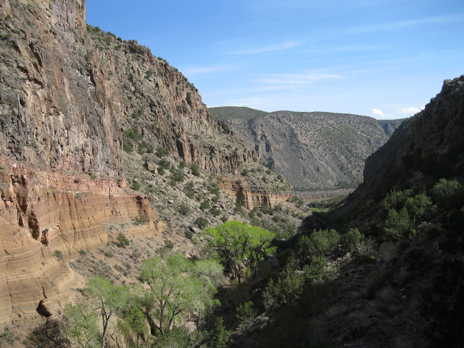
There is a 700 foot drop from the trailhead down to the junction with the Rio Grande River. The micro climate below is drier and spring arrives a couple of weeks earlier than higher in the canyon. The trail guide points out that the lower layer of smoother looking rock was formed by a maar volcano.
A maar volcano ejects lava through water such as a lake or aquifer. The material spit into the air was re-deposited as thin layers. The mountains in the distance are old volcanoes that produced the basalt layers along the trail.

The Upper Falls drops 80 feet over some of the resistant rock from the throat of the volcano. Some of the maar layer is visible as are the higher lava flows.

The main trees visible in Frijoles Canyon are Pinion Pines, One-Seed Junipers and the tall Ponderosa Pines. Abert or tassel eared squirrels occur here but I didn't notice any during my hike. Along the stream there are Narrowleaf Cottonwoods, Box Elders and Thinleaf Alders. In early spring these leafy trees were just starting to develop their leaves. My hike took 1:30 hours for the 3 miles on a 65 F degree early April afternoon.
(A Bandelier Park Ranger has provided some additional tips for the Falls Trail in the comments.)
1 comment:
Hi - I'm a ranger at Bandelier and want to thank you for doing a nice job with this, especially on being up-to-date concerning the part of the trail that is no longer open. It might be worthwhile to advise hikers that pets aren't allowed on Bandelier trails, and since the trail loses 400 vertical feet going (and therefore is 400 feet uphill returning) it's more important than usual to carry plenty of water. Thanks!
Post a Comment