Tuesday, December 29, 2009

Monument Valley vs. Valley of the Gods

Monument Valley along the Utah and Arizona border and inside the Navajo Nation draws visitors from around the world. The massive carved sandstone buttes with the overlay of Navajo culture help visitors connect to the land like few other places. Not far from Monument Valley, on the north side of the San Juan River is the similar but less noticed Valley of the Gods.

Most visitors visit Monument Valley on the 17 mile Self Guiding Trail. Along the route are 11 numbered scenic stops. The best known of the stops are the two Mittens, among the most iconic rock formations in the west.


The towering formations are described as being eroded De Chelly sandstone, capped with the harder Shinarump formation. The De Chelly is also visible at the spectacular Canyon De Chelly Monument near Chinle in the center of the Navajo Reservation. Among my favorite formations along the trail is the Totem Pole and the Yei bi cheis.


If you approach Monument Valley along Highway 163 west of Bluff, Utah you will pass by the less known and lightly visited Valley of the Gods. This BLM area also has a 17 mile self guiding trail and the many formations have local names. The Valley of the Gods formations are described as being carved from Cedar Mesa Sandstone, but I think this is equivalent to the De Chelly sandstone.

Near the Valley of the Gods is the formation called Lime Ridge, important in Navajo beliefs. A trapezoidal formation that resembles the traditional Hogan dwellings holds the trapped children who were disobedient to the Sun Bearer and are being punished. When the children did not repent, the Hogan was turned to solid rock. It occurs to me that using the landscape to symbolically represent traditional stories is similar to rock art. Modern visitors often seek to find hidden petroglyphs and pictographs, but the entire landscape can be viewed as rock art also.


Besides the Monument Valley Self Guiding Trail, visitors can take guided tours into Mystery Valley and the Back Roads of Monument Valley. On these tours, some of the many Ancestral Pueblo ruins sites and rock art sites can be visited, along with several natural stone arches.

The harsh dry nature of the environment makes it hard to believe that people could live here, but there are several rock alcoves that sheltered small structures. The back roads also pass by the springs that provided water for these agricultural residents.


There aren’t any tours in the Valley of the Gods, The short brochure reminds visitors not to disturb any archeology sites, but there isn’t any information about where they might be. On my own visit I didn’t stray from the road, but there may be a good hike up Lime Canyon here.

The Cedar Mesa area just to the north is rich with ruins sites in the deep canyons and on the canyon rims. There may not be much water available in the Valley of the Gods, but there was a small spring in the vicinity of the Bed and Breakfast near the west end of the road.


Wednesday, November 25, 2009

Simon Canyon Trail near the San Juan River

Simon Canyon is a side canyon along the San Juan River just below the Navajo Dam in northwest New Mexico. The trail head is at the end of 3 mile County Road 4280, off of New Mexico Highway 173 about 18 miles east of the town of Aztec. 


The Simon Canyon Natural Area is a 3900 acre BLM area adjacent to the Navajo Lake State Park.

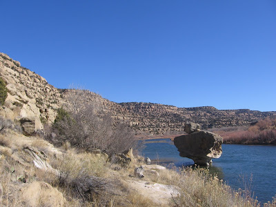
The Simon Canyon Trail begins at the same point as the San Juan River Trail, which travels east along the clear cold tail water below Navajo Dam. The early part of the trail is a service road along the east rim to a gas well, with the River Trail splitting off to the right.

Past the gas well the foot trail continues along the ledge above the cottonwood trees and riparian habitat of the creek bottom. The habitat along the trail is Pinon Pines and Utah Junipers with scattered shrubs like sagebrush, Mormon Tea, and Prickly Pear Cactus.

About 0.8 miles along the trail is a small ruins site that is associated with the Gobernador era of the Navajos, from 1700 to 1775. There are several similar sites in the region of Navajo Lake, with this one being the northern most. This one is thought to have been vulnerable to Ute raids, leading to the abandonment of the area.

In the Gobernador era, it looks like Navajos were building village style structures, whereas they now live in more dispersed camps. The later Navajo structures that we see now emphasize the Hogans that used Juniper logs and were packed with soil for insulation.

The doorway for this small structure appears to be on the north side. Most current Navajo structures emphasize an eastern entrance to face the morning sun. There is an interpretive sign at the site that indicates that the roof is still mostly intact, but it would be difficult to climb up and view it. I turned around after viewing the ruin for a hike of about 1:00 hour. It looked like a hiker could continue further up the canyon shelf or along the creek bottom.

528614_Cool Camo Russell Outdoors

Tuesday, November 24, 2009

San Juan River Trail below Navajo Dam

The San Juan River Trail is a 2.5 mile round trip along the north side of the San Juan River below Navajo Dam in northwest New Mexico.

The trail head is at the end of County Road 4280, north off of New Mexico Highway 173, 18 miles east of the town of Aztec. The hike to the Simon Canyon Ruins starts at the same point.

The trail starts along a service road that heads up the east rim of Simon Canyon. The San Juan River Trail branches off to the right, heading up river. On the day I hiked, I saw a sign post at the trail junction, but not a sign.

The tail waters flowing below Navajo Dam are clear and cold and make this area a very good trout fishing area. On a cool but sunny late November day, I saw several fly fishermen standing thigh deep and casting for trout. One of the landmarks along the trail is called ET Rock. Further on is Lunker Alley. This area doesn’t allow motorized boats and I saw a few rubber rafts with paddles maneuvering in Lunker Alley.

The sandstone cliffs along the trail are part of the San Jose formation, deposited 50 million years ago. The San Jose is a relatively recent layer compared to what is mostly visible in the Four Corners area. The youngest rocks in view at the top of Mesa Verde are 70 million years old, and the Entrada Sandstones at Arches National Park are 180 million years old. The canyon sides are covered with Pinon Pines and Utah Junipers with patches of sagebrush. Close to the river banks are cottonwoods and tamarisks. There are a few benches and tables along the trail and several places to fish from the bank.

The trail seems to end sooner than it needs to. My hike took 1:20 hours for the 2.5 mile round trip on a 44 degree sunny day in late November. There is a similar Simon Point Trail along the south side of the San Juan between the fishing access points.

The area above and below Navajo Dam are mostly part of Navajo Lake State Park with many campsites, day use areas and boat launch facilities. Navajo Lake is 15,000 acres and is the second largest lake in New Mexico. Navajo Dam is 3800 feet long, 400 feet high, and was constructed between 1958 and 1962. The longest arm is 25 miles long and the elevation is 6085 feet. There is a short hiking loop at the Pine Campground from the campground to the lake.


The San Juan River Fly Fishing Guide (Below Navajo Dam, New Mexico) 18407_$5 Shipping on Orders of $99 or More!

Saturday, October 31, 2009

Gallo Alcove Ruins at Chaco Canyon

The Gallo Alcove Ruins are located in the campground at Chaco Canyon National Monument in northwest New Mexico. Chaco is known for the very large Great Houses, but it also has an example of the smaller alcove type structures that are often found in the Canyons of the Ancients and the Cedar Mesa area of southeast Utah.

These two side by side sites are probably not noticed by visitors not staying in the campground, though they are visible along the road on the way in. There isn't a trail to follow except to make your way across the campground.

These small sites were occupied at the same time that the Great Houses were in use and might be typical of how the average members of the farming community lived. I noticed at least two more small ruins along the road leading to the Visitor Center, but no attention is called to these sites.

In the vicinity of the small ruins and the Gallo campground, there are several petroglyph panels. The campground panels are mostly examples of ones that have been damaged by visitors. There are some interpretive signs that display how the panels are supposed to appear compared to how they actually appear.

The Gallo campground also has a 1.5 mile trail that doesn't appear on the park map. It  leads to a lookout point above the east part of Chaco Canyon.


Wednesday, October 28, 2009

South Mesa Trail at Chaco Canyon

The South Mesa Trail is a 4.1 mile loop to the mesa top Tsin Kletzin ruins site in Chaco Canyon in northwest New Mexico. The trail head is the same as the Casa Rinconda Loop Trail and a hiker will hike at least half of this loop trail on the way to the start of the South Mesa.

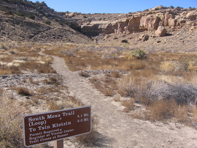
After passing by the large Great Kiva site of Casa Rinconda and the small villages nearby the trail climbs 450 feet to the mesa top. There are great views of the canyon floor with the nearby Great Houses clearly visible. The mesa top site of New Alto on the north side of Chaco stands out and you can imagine that the two sites could signal to each other and to other distant sites.

After reaching the mesa top a ruins site appears on the horizon and seemed to be further away than it appeared. The Tsin Kletzin site is D shaped and has about 70 rooms and dates from about 1112 AD. At this site there are tall walls on the curvy part of the D that faces the south and short walls to the north.

At the canyon floor sites where the open plaza faces the south, the tall walls were to the north against the canyon wall. The masonry at the back wall appears to be more same sized blocks rather than the style using alternating large and small block bands.

One of the large kivas is easy to view and here a banding of large and small is visible. The landscape surrounding Chaco Canyon is very visible from this mesa top position. The Chuska and Lukachukai Mountains are visible to the west.

This was the area where much of the wooden beams used at Chaco would have come from. The trees mostly available in those mountains are the tall straight Ponderosa Pines.

Another distant formation that is easily visible is Huerfano Mesa to the northeast. This mesa has three buttes that stand out and is along Highway 550. Huerfano is thought to be one of the signaling sites that the Chaco people used. Huerfano Mesa is also one of the sacred inner mountains of the Navajo.

The Hero Twins of Navajo Mythology were born there. Changing Woman was the mother of the Hero Twins and she lived in the first Hogan there. It is the “lungs” of Navajo country. On the day I hiked I couldn’t see the LaPlata Mountains or Mesa Verde but I did see the spike of Shiprock, all to the north.

The return leg of the loop gives some good views of the south gap, a travel route out of Chaco Canyon. As the trail returns toward Casa Rinconda several of the other Great Houses come into view. There aren’t any Chaco features pointed out with signs on this trail as the Pueblo Alto Trail does. It took me 2:15 hours to walk the 4.1 miles on a 55 F degree blue sky late October day. I carried 2 liters of water.


Tuesday, October 27, 2009

Chaco Canyon Petroglyph Trail

The Petroglyph Trail at Chaco Canyon in northwest New Mexico runs for 0.25 miles along the base of the canyon wall between the large Pueblo Bonito and Chetro Ketl Great House sites.

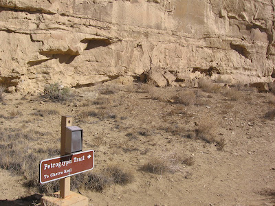
There is a printed trail guide with 12 stops describing the features along the trail. I started at the Pueblo Bonito end of the trail. The Pueblo Bonito site is the largest and most famous of the Chaco Canyon sites. Most of the images on the trail are faint and it helps to have binoculars to see the ones placed high on the canyon walls.
Most of the attention at Chaco Canyon is directed toward the very large structures, but there were many small unexcavated structures here, where most of the residents lived. Along the trail there are carved holes in the sandstone where wood beams were supported. Grooves in the sandstone are frequently seen and are thought to be places where stone tools were sharpened.

The first stops along the trail have some historic inscriptions from explorers and early European residents. There is also a discussion of the techniques and tools with pecking, abrading, incising, and drilling all combined to form images. A bird image is pointed out as a good example, though it is difficult to see.

There is one small site with some wall fragments still in place. Petroglyph panels are often associated with building sites. The trail guide mentions that many of the Chaco petroglyphs include spirals and open-armed and open-legged stick figures. These images often face south or east. There is no accurate ways to place a date on rock images but the age of the buildings may be a clue.

Chetro Ketl and Pueblo Bonita are large sites that are very close together and one can imagine that there was a lot of foot traffic between the two sites along this canyon wall. There are other petroglyphs to see on the Una Vida Trail near the Visitor Center and the Penasco Blanco Trail. The Wijiji Trail has a pictograph panel. I spent about 40 minutes on this segment of trail between the two famous Great Houses.


Thursday, September 24, 2009

Angel Peak Trails

The Angel Peak Scenic Area is a 10,000 acre badlands area about 15 miles south of Bloomfield along Highway 550 in northwest New Mexico. Most visitors will enjoy the views from the three rim overlook areas or the campground. There aren’t any official trails but there are some at least two reasonable routes for a hiker.


The small campground is at the end of the rim road. There is a short trail in the campground that leads along the rim to several view points toward 7000 foot Angel Peak. At the east end of the campground the trail leads through an odd turnstile and continues toward an eroded ridge with two fragment peaks of sandstone that is between the campground and Angel Peak.

The route approaching the two peak fragments is something of a knife edge. The way the two peaks line up is similar to the Chimney Rock formation and ruins site near Pagosa Springs, CO. I went as far as the first peak and thought it got too steep after that, but it may be possible to go further.

There are steep layers of sandstone below the clay layers and there is no established route to get to the canyon bottom. I saw a trail on the slopes back toward the campground that looked too steep for hikers and I thought it might be trail for Big Horn Sheep or other wildlife.

There are roads in at the bottom of the badlands but they don’t connect to the rim road in the Scenic Area. There are many gas or oil wells in the area and many service trucks traveling along these roads. My hike along the campground out to the eroded peak and back took about 1:15 hours.

There are other places in the campground area to hike a little below the rim on the clay layer but not many gaps in the sandstone layer and a descent anywhere toward the bottom will be steep.

I found another short hike at the Castle Rock Overlook and Picnic Area. Castle Rock is the second of the three overlooks. The first is named the Sage Overlook and the third is named the Cliffs Overlook. I didn’t find any interpretive signs or brochures in this area describing the geology or biology. The plant life in the badlands is very sparse. It looks there are scattered Junipers along the washes at the canyon bottom.

There is a short trail leading to a view point of a large Castle Rock far across the canyon and a smaller Castle Rock that can be reached by hiking. The trail is a little vague, but you can see where you are headed.

The views from Castle Rock extend beyond the immediate Angel Peak area. To the north the LaPlata Mountains near Durango, CO are visible. Also, Sleeping Ute Mountain and Mesa Verde can be sighted. This short hike takes only 30 minutes.


Tuesday, September 22, 2009

Cox Canyon Arch Trail

The Cox Canyon Arch Trail is in the canyon country in northwest New Mexico about 3.5 miles south of the Colorado border along Highway 550. The unmarked trail head is west along County Road 2300 for 1.2 miles, then a right turn on County Road 2310 for 2.5 miles, then a right on a dirt track past a gas compression facility.

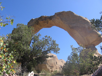
At the end of the dirt track past the gas plant there are two short side canyons to the left or north and the arch isn’t visible. The unmarked trail starts up the side canyon that is more to the left or west. The arch sits in the area that is between the heads of these two short side canyons.

I walked up the wrong side canyon at first and came to a dead end. There is a shady alcove at the end but I didn’t see any way up to the rim. I retraced my steps and crossed the dry wash and looked over to the east. I spotted the arch in the distance from the sage brush field as I was returning.

There are two layers of short sandstone cliffs to climb past on the way up. I had to look around for a few minutes to find the first notch to climb through. It looks like a step has been carved to make the climb easier. The second cliff is a little trickier, but some handholds have been carved making that spot feasible.

There is an alcove at the head of this short canyon just below the arch. I looked briefly to see if there might be a ruins site there but didn’t see anything. This arch has a 42 ft. span and is 35 ft. high. It somewhat resembles Delicate Arch in Arches National Park and is easy to view from both sides. The return hike only took 15 minutes and my total hike was about 1:20 hours with much of that time spent trying to find the arch and the route.


Thursday, July 2, 2009

El Moro National Monument Trail

The El Moro Trail is a 2 mile loop that visits the historic Inscription Rock and the Atsinna Pueblo ruins site at El Moro National Monument in northwest New Mexico. El Moro is a sandstone bluff or headlands that rises above the Pinon Pine and Juniper surrounding landscape.

For centuries travelers have stopped at El Moro for the pool of cool water that collects in a pocket on one side of the bluff. There isn’t a spring here, but the pool holds water throughout the year. The visitors here left their marks in the sandstone walls near the pool. Now there more than 2000 historic and pre historic inscriptions.

There are 23 interpretive stops on the Inscription part of the trail and a trail guide that gives some of the history of those who stopped here. Several of the main trees of the area are also identified with signs, making this a botany trail also. I noticed that there are more species of Juniper trees here than are usually seen in one place.
Some of the older American Inscriptions are associated with the U.S, Army scouting party surveying a route from Ft. Smith Arkansas to the Colorado River in 1857. This survey party was also testing to see if camels could be used more effectively in the desert environment of the southwest. Many of the inscriptions are white on white and hard to see. In the early years of the park, some efforts were made to darken the writing with carbon.

One of the oldest Spanish inscriptions is from the first governor of New Mexico, Don Juan de Onate in 1605. The Spanish inscriptions often include “paso por aqui”- passed through here. I notice that the Spanish inscriptions here tend to be in a swirly script, like hand writing. There are also Ancestral Pueblo petroglyphs in several places featuring mountain sheep and handprints and there is one bear paw.

After the 0.5 mile Inscription portion of the trail, the route climbs to the top of the bluff giving good views over the surrounding countryside. It looks there is a small vertical arch forming near the top of the bluff. Arriving near the top there are some wall sections visible from a large unexcavated ruins site. The trail over the bare sandstone was marked by chipping parallel lines, forming a lane, and there are many steps carved into the rock.


On the bluff top, the trail winds around the edge of the sandstone bluff, making towards the Atsinna Pueblo ruins site. This is a very large site with maybe 800 rooms, but only a few are excavated. This site is thought to have been occupied from 1275 to 1400 by the ancestors of the Zuni people who have a reservation in the area.

Among the 18 excavated rooms is a Great Kiva. The dates of occupation here are a little later than many other sites in the Four Corners region. Most of the Mesa Verde sites to the north are thought to have been abandoned by the time that Atsinna was just being constructed.

This trail takes about 1:30 hours depending on how long you linger at the many points of interest. There are many benches for resting and enjoying the views. I walked the trail in late June on a 78 F degree day and carried one liter of water. The bluff top is about 200 feet above the inscription covered base.


Wednesday, July 1, 2009

Bandera Volcano Trail-El Malpais

The Bandera Volcano Trail is located a few miles to the east of El Moro National Monument along Highway 53 in northwest New Mexico. It is a privately owned attraction with a $10 entrance fee. This area is known as the El Malpais region, an area of lava flows and volcanoes.

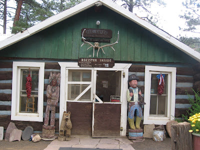
The starting point for the Bandera Volcano and the shorter Ice Cave Trail is the Old Time Trading Post. The trading post was built in the 1930s during the period when the Zuni Railroad was operating and the timber industry was booming. The trail is like a wide cinder covered road and there is a trail guide with markers along both trails. The hike to the volcano is about a 1.5 mile round trip and the Ice Cave is another 0.5 mile round trip.

One of the points of interest along the volcano trail is a spatter cone. These are formed when a minor vent of hot air breaks through to the surface to form a blow hole.

The volcano trail winds around the outside of the crater and enters through an opening where the lava tube formed and lava flowed out the side. The Bandera Crater is the largest in the region and erupted about 10,000 years ago. The lava flow is nearly 23 miles long. The crater here is 1400 feet wide at the top and 800 feet deep with the trail lookout point about 330 feet below the rim. It is interesting that the lava and cinders can support forest growth. This area has Ponderosa Pines and a few Douglas Firs mixed in with Pinon Pines and Junipers.

The path to the Ice Cave passes through a similar forested landscape on top of a lumpy lava surface with sink holes and lava tubes. At the Ice Cave there are uneven wooden stairs leading down into deep hole, with the air getting noticeably cooler with each step. Cold air settling into the hole and the thick insulation keeps the bottom frozen year round. In the early years of the trading post this cave was a source of ice to keep the beer cold.

The ice is thought to be 20 feet thick and the green color is due to a cold tolerant algae. The oldest ice at the bottom is thought to be 3400 year old. It took me about 1 hour to walk these two trails


Tuesday, June 30, 2009

El Calderone Trail in El Malpais

The El Calderone Trail is a 3 mile loop that explores some of the volcanic features of the El Malpais National Monument area in northwest New Mexico. The Trail Head is along Highway 53 south and west of Grants, NM. This trail has an interpretive guide with seven stops.

The first point of interest is Junction Cave right at the trail head. Junction Cave is a lava tube created by lava flows from nearby El Calderone cinder cone and is thought to be 115,000 years old. Junction Cave can be entered if you are properly equipped with hard hat, gloves, and at least three flash lights.

The interpretive guide discusses the types of life that use caves, with most of it being very small species. The cave information indicates that there is at least about 500 feet of tunnels here.

Another feature is the Double Sinks, the trail passing right between two very large holes, each about 80 feet deep. The terrain here is a bumpy lava surface covered with grass with scattered pine and juniper trees. There are both Pinon Pines and Ponderosa Pines.

The lava tubes and trenches have an effect on the environment in that water runs off collects around the edges, making the edges moister than they would be otherwise. The extra moisture allows better growth in specific spots.
Bat Cave is another of the highlight features. Bat Cave is also a lava tube and provides habitat for several species of bat. The Mexican Freetailed Bat uses the cave in the summer and migrates south for the winter. Little Brown Bats, Pallid Bats, and Townsend’s Big Eared Bats are year round residents.

There is an interpretive sign here that mentions that bats can eat up to 600 mosquitoes per hour. The world has about 900 species of bats with 10 having been found in El Malpais. (In 2011, the bat caves of El Malpais have been closed to recreational use due to the fungus associated White Nose Syndrome bat illness that has been spreading across the country.)

There were at least two eruptions at El Calderone. One created the black cinders and the other created the red cinders. The red cinders contain a higher amount of iron. The trail guide mentions that lava bombs up to three feet in diameter were hurled from El Calderone and can be observed along the base.

The crater of El Calderone has a good growth of Ponderosa Pines. The trail into the crater runs along a long lava trench that exits from the side of the crater. I walked this 3 mile trail in about 1:15 hours, but I was in a hurry as there was a summer thunderstorm threatening. The route is smooth without much elevation change and is graveled part of the way. It was an 80 F late June day and I drank a liter of water when I finished, after not drinking any during the hike.