The Pyramid Trailhead is straight ahead on the main park road past the extensive rodeo facilities. The Pyramid Trail is one of the most popular in the Gallup, NM area. There is an aerial photograph map of the trail at the information kiosk but in early 2012 the image is faded and hard to read. The exact mileage isn’t posted but this hike felt like about 4 miles roundtrip and climbs steeply toward the end.
There are several interpretive signs along the Pyramid Trail. The first describes the area geology. The layers listed start with the eye catching Church Rock formation and work down. Visible up above are the Dakota, Morrison, Zuni, Bluff, Summerville, and Todilto layers. The base rock is the Entrada Sandstone that Four Corners travelers will recognize as the layer with all the Arches near Moab, Utah.
Further on there is a view toward the historic Fort Wingate. The Fort was established in 1868 with the return of Navajos from Bosque Redondo and served as a distributer of “Navajo Treaty Goods.” There are many bomb proof armament storage igloos visible that date from World War II. The Fort Wingate Indian School developed the first group of the famous Navajo Code Talkers.
After the first segment of climbing there is a relatively level segment along a ridge and Pyramid Rock first comes into view. An interpretive sign mentions the common plants and their uses for the original natives of this area. I kept an eye out for Ancestral Pueblo ruins along the trail but didn’t notice any. There are alcoves in the canyons along the way that could shelter some sites but they are a long distance away.
The last segment of trail curves around the Pyramid and climbs all the way to the top. There are a couple of balanced rocks on the way to the top. The Pyramid Rock Trail was constructed over three seasons by the Youth Conservation Corps and they continue to provide maintenance.
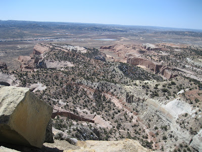
The last segment of trail is steep but there are constructed steps making the climb easier. From the top of Pyramid Rock there are outstanding views in all directions. The cap rock of the Pyramid is Dakota Sandstone providing a relatively smooth surface and some large boulders to sit on.
It took me 1:10 hours to climb to the top and 0:50 minutes to descend for a total hike of 2:00 hours. I hiked on a 60 F degree mid March day and carried 2 liters of water. There were about 15 other hikers on the trail during my hike.


No comments:
Post a Comment