Canyon de Chelly National Monument is entirely inside the
Navajo Indian Reservation in NE Arizona. Besides being a spectacular natural feature with 700 foot sheer sandstone walls, it has two cultural overlays.
It is the traditional center of Navajo territory since their arrival in the area 500 years ago, and it has ruins of the collapsed Anasazi pueblo culture that moved out 700 years ago.

The rim drives are open at all times but the inner canyon is restricted. A good way to see visit the rest of the canyon bottom is to take one of the 4 wheel drive tours. The tour I took started at the Thunderbird Lodge and entered at the canyon mouth. The tour lasted nearly four hours and started up the north arm, called
Canyon del Muerto continueing to just past the
Antelope House ruin.

There were about 20 on the tour in a big 4 x 4 truck outfitted with padded seats. The driver was a Navajo whose family had a camp in north arm and who had been giving tours for 27 years.

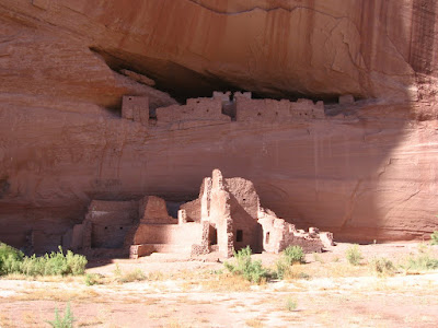
The
Antelope House Ruin is visible from above at one of the overlooks along the north rim.
Navajo Fortress is visible from the same area.

Along the way. besides the ruins and the lush scenery at the canyon bottom, we passed the summer activities of Navajo families, some farming and herding, and children playing in the water.
The massive cliffs that form the
walls of the canyon are De Chelly Sandstone. The De Chelly Sandstone was deposited as dunes in an arid environment about 250 to 230 million years ago. The caprock along the canyon is known as the Shinarump Conglomerate, a layer of stream deposited sand and gravel.
We turned around and went back down Canyon Del Muerto and up the Canyon de Chelly arm to the
White House ruins. This ruin can be visited by trail also.
There is a lot of rock art along the way in lower parts of the Canyon de Chelly. The tours may go past these sites quickly, or the views may just be from the vehicle. Near the Canyon mouth is
Kokopelli Cave. On the left side of the cave are pictographs of handprints and a reclining flute player.
There is also a site near the canyon mouth called
Newspaper Rock and Triangle Man just across from it. Newspaper Rock has many images but they are hard to see without binoculars. Whether the tour stops at these sites might depend on the guide.
A short distance before the Antelope House is a site called
Black Bull Cave. Here there are some broad shouldered painted figures and hand prints. The yellow image is a flute player but is hard to see.
(I later took a tour in a jeep and saw some more of the details in this area, particularly the small ruins sites. Use the label "Canyon de Chelly Tours".)

 The main attraction is to stand on the plate, or better yet get down in the push up position so you have a limb in each state.
 The monument is nicely constructed, with a platform providing some elevation for picture taking. There is some interpretive information giving the history of the surveys in the area.
 Surrounding the monument is an array of flagpoles, with every political entity represented. The surrounding terrain appears to be clay hills and some eroding rock with very little vegetation.
 The other highlight is the Navajo Market. There are numerous booths and stands for the vendors to sell artwork, food, and souvenirs. Have a Navajo Taco, very tasty.
 The hike begins at the White House Ruins overlook. There is a short walk along the rim before the trail begins to descend. This is the only trail in Canyon de Chelly that allows hiking into the inner canyon without a guide.


 One story has it that she is the one who gave the gift of weaving to the Navajos. Navajo weaving has become an art form. This is practiced mostly by women and there are many traditional and modern designs.


 The Antelope House name is from some antelope drawings made by a Navajo artist in the early 1800s. The inner canyon tours stop at Antelope House and some arts and crafts are usually on sale there. It is thought that construction at this site began around 700 AD and continued for 600 years, on and off. Gazing out across the canyon, there are views of the shear sandstone walls and the stream that runs along the bottom.
 The sandstone cliffs in Canyon de Chelly are 600 feet high. The Mummy Cave Ruin way down below is one of the largest pueblo villages in the canyon and was occupied until about 1300.


