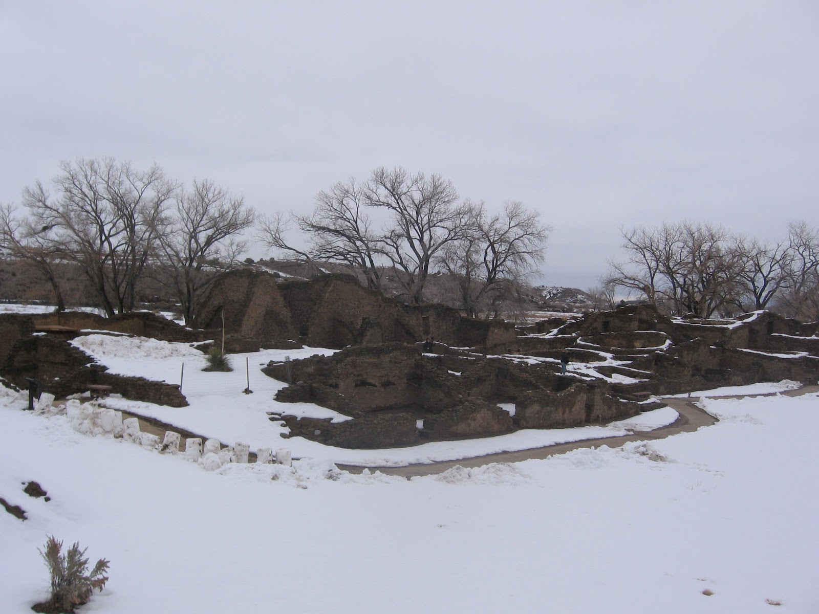
The trail at
Aztec Ruins National Monument is cleared for winter visiting of this very large ruins site in northwest New Mexico. Aztec Ruins is thought to have been influenced by both Chaco Canyon and Mesa Verde before being abandoned around 1300 AD.

One of the striking features of Aztec Ruins is the
green band of stones along the first part of the 700 yard trail. The masonry styles are of interest in these sites as there are distinct differences from different regions and different time periods. The sandstone used here was carried by hand from quarries several miles away. There are other shorter segments of green bands near the end of the trail.
The thick stone walls and the snow bring to mind the business of keeping warm in the winter. Stone isn’t a good insulation material and thicker walls would be useful for preserving heat. The thick walls also would support the upper levels of the structure.
The question might be which was more important, having upper stories or having more insulation? The below ground kivas would also provide some earth contact shelter from the harsh winters. The kivas are designed with ventilation shafts and a roof opening to allow smoke to escape but the extensive room blocks at most sites are not.

I haven’t seen the concept of
thermal mass mentioned at any of the ruins sites in the Four Corners region. In arid climates, the building material will absorb solar energy during the day and release the stored heat during the cool evenings. The effect is to dampen the temperature swings and make the internal space more comfortable. Adobe houses take advantage of thermal mass. The earth packed
Hogans of the Navajo would also.
The Pit Houses of the ancestors of Aztec Ruins take advantage of both thermal mass and earth contact. The alcove sites at Mesa Verde are mostly south facing to catch more of the winter sun. At Aztec Ruins the entire site is south facing, the open plaza faces the south and the back wall faces the north.
There is also a question of fuel for these sites also. The main trees that grow in the area are Pinon Pines and Utah Junipers. In the better soil areas sage brush grows. Interpretive information from around the region suggests that the Pinon Pines wouldn’t be cut down as they provide a nutritious and high calorie nut.
The sagebrush cleared from farming fields would be a good candidate for fuel as it burns hot. There are Cottonwood trees nearby along the Animus River. The interpretive information says that Cottonwood would be burned in summer as it provided a bright light but not much heat.

I noticed two
grinding stones along the sidewalk near the visitor center. The visitor center has a small museum with a few artifacts and displays and a video room. One interesting pottery piece has a spiked surface that might be modeled after the seed pod of the highly toxic, hallucinogenic Datura plant.
My visit at Aztec Ruins was for about 2:00 hours on a 37 F degree late January day. The trail was clear with a few icy patches. There was about 1 foot of snow in the uncleared areas.

 One of the interpretive signs along the trail explains the formation of petrified wood. Approximately 225 million years ago this area was a flood plain littered with fallen trees. Buried under layers of silt, the silica laden waters petrified the wood by encasing the organic material with minerals.
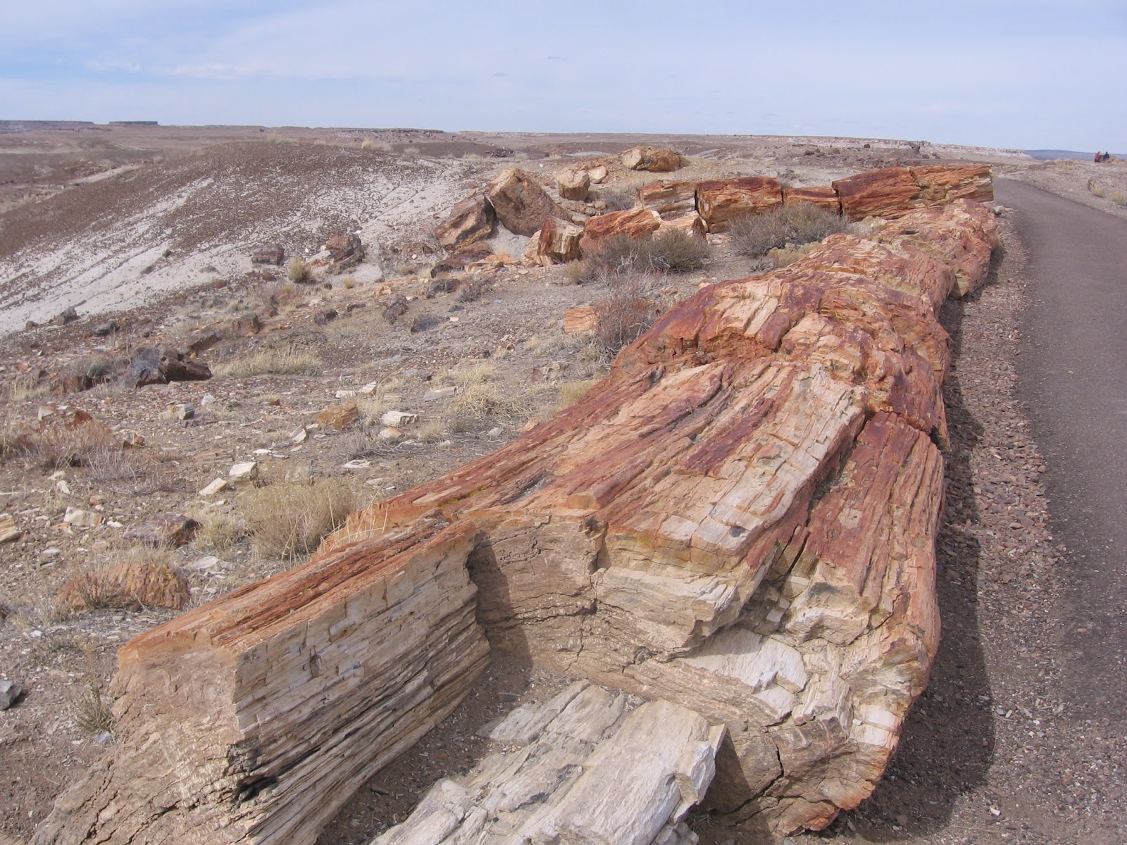
 I walked the Crystal Forest Trail on a mild 55 F degree day in early March. This short trail is similar to the nearby Long Logs Trail but has fewer examples of long tree trunks. Another nearby overlook site is the Jasper Forest. From the rim area, tons of petrified wood is visible in the valley below.
 The badlands are areas of mudstones and siltstones that are easily eroded and sculpted by wind and water. The first part of the trail descends steeply through the sandstone caprock layer that is described as a conglomerate, containing gravels that were deposited by a moving stream.

 This is a small ruins site but it is unusual in the Canyon de Chelly as it is near the canyon rim rather than near the canyon floor. Most of the ruins sites at Canyon de Chelly are near the farming fields, peach orchards and water supplies that make the floor area livable.
 In winter, the roads to the overlooks and parking areas are cleared of snow. The climate today at the mouth of the canyon is mostly dry but the upper ends of the canyon catch the winter storms. The melting snows make this area one of the best watered areas of the Navajo Reservation. There are seven overlook areas on the south rim and three on the north rim. Only the White House Ruins Trail can be hiked without an official guide.


