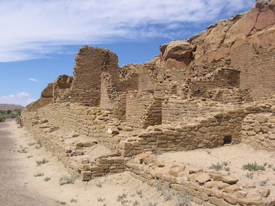
The Penasco Blanco Trail is useable by mountain bikers as well as hikers. It follows the Chaco Canyon floor to the west along the north side of the canyon. The total walk out to Penasco Blanco and a pictograph site is about 3.7 miles but the last part was closed in September 2008 due to flooding along the wash.
After about 0.5 miles the trail arrives at the Kin Kletso ruins site. Kin Kletso was among the last of the Chaco structures, built around 1120 to 1130. Pueblo Bonito was more that 250 years old by then. It uses as different style, rectangular rather than D shaped.
The masonry style uses more or less same sized, loaf shaped stones rather than the layers of large and small in the earlier periods. Another back country trail, the Pueblo Alto Trail branches off here at Kin Kletso and climbs to the mesa top to sites up above.
 After another 0.7 miles Casa Chiquita comes into view. This site is similar to Kin Kletso in the style and period when it was built.
  The rectangular style is thought to show the influences of the Ancestral Pueblo People who lived in the Mesa Verde area about 140 miles to the northwest. Mesa Verde is best known for the structures sited in alcoves on the sides of canyons, but there are also large mesa top pueblo sites. The Far View Trail in Mesa Verde has some good examples.
 A little past Casa Chiquita there is a parallel trail that passes several petroglyph sites. Six are pointed out with small signs, but there are more than that. Some are at eye level and some high on the side of the canyon walls. The panels represent different cultures and periods of time. Some are at eye level and some high on the side of the canyon walls.
 This one was particularly high and in a spot where you wonder how anyone got up there to do some art work. The human figure seems to appear in many locations around Chaco Canyon. The lower left figure looked like a flag at first but it seems to also be mounted on a post. It is thought to be a Kachina. The end of the petroglyph loop is 1.7 miles from the parking lot. I headed back from there,
(There is another post about the next segment of trail, use the labels for Penasco Blanco Trail. The Chaco Wash was flooded on this visit also.)


1 comment:
Interesting photos and blogging!
Post a Comment