Around the perimeter are 15 rooms with ladders and small doors. These small rooms had doors out onto the plaza also. It is not known what these rooms were for. The large beams in the roof would have had to been brought from many miles away as the immediate environment around Aztec Ruins doesn't support large trees.
Trails in and near the Navajo Indian Reservation in the Four Corners area of Arizona and New Mexico. Inlcudes Canyon de Chelly, Petrified Forest, Monument Valley, Bandelier, El Malpais, Chaco Canyon, and more. Trail notes and pictures.
Saturday, May 31, 2008
The Great Kiva at Aztec Ruins
The final stop on the Aztec Ruins Trail is the Great Kiva. It is situated in the center of the plaza of the west ruin, a huge site with at least 400 rooms.
The Great Kiva at Aztec Ruins in northwest New Mexico is the only reconstructed Great Kiva of the dozens in the southwest. It was reconstructed in 1934 based on the remnants of the original building.
Entering the Great Kiva is something like entering a church. The kivas were thought to be used for religious purposes and were constructed down into the earth, entering the realm of the spirits. "Show respect" the interpretive signs remind visitors.
The inside is nicely plastered and painted in red and white. It is easily forgotten that most walls at these ruin sites were plastered and decorated. Now, we mostly just see the raw stone work, weathered for 700 years.
Around the perimeter are 15 rooms with ladders and small doors. These small rooms had doors out onto the plaza also. It is not known what these rooms were for. The large beams in the roof would have had to been brought from many miles away as the immediate environment around Aztec Ruins doesn't support large trees.
Four large columns support the 95 ton roof. The foundation for the columns were four limestone disks, which had to have been carried from at least 40 miles away. The feeling I got from the interior was like it was a nice reception area for an upscale resort.
From the exterior you can gaze in through the door of one of the 15 surrounding small rooms. The interpretive literature at these southwestern ruins sites doesn't mention where visitors and travelers stayed. That's how the Great Kiva's outer rooms struck me, as a nice place for visitors.
Around the perimeter are 15 rooms with ladders and small doors. These small rooms had doors out onto the plaza also. It is not known what these rooms were for. The large beams in the roof would have had to been brought from many miles away as the immediate environment around Aztec Ruins doesn't support large trees.
Tuesday, May 27, 2008
Aztec Ruins Trail
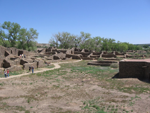
Aztec Ruins National Monument is an large Ancestral Pueblo site near the Animas River in northwest New Mexico. It is misnamed, as is the town of Aztec, NM as the Aztecs of central Mexico had nothing to do with this area.
The West Ruins has been excavated and is a massive structure of about 400 rooms with three stories, with very thick walls. There is an equally large East Ruins that remains unexcavated and is not open to the public except on special tours. The trail that winds around the West Ruins is short, about 700 yards, but there is a lot to see.
It is thought that Aztec Ruins was originally occupied and influenced by the Chaco Canyon culture. Chaco Canyon is a major site about 55 miles to the south and was the main center of Pueblo culture until about 1100 AD. The center of Pueblo Culture shifted north to Mesa Verde after 1100 and Aztec Ruins shows these influences also. The inner walls here show the alternate sized bands of stones of the Chaco style and the outer walls show the more even sizes of Mesa Verde style.
There are a few places at Aztec where doorways are placed at corners, a rare feature and unique to the Chaco style. This was risky as it weakened the walls. One of the reasons that these structures eventually failed is that walls were not bonded well. Many of these walls were without solid foundations. As the walls settled, they tended to separate at the weak corners.
A structure just outside the main walls is called the Hubbard Tri-wall site. The space between the three concentric walls was divided into eight rooms in the inner circle and fourteen in the outer, with a central kiva. The site has been filled in with dirt to keep it from collapsing. Tri-wall sites are rare, but there is another one to see in Chaco Canyon at Pueblo del Arroyo site.
The environment at Aztec is dry and nearly desert, with only sparse Pinon Pine and Juniper trees growing. There was abundant water however from the Animas River, flowing down from the San Juan Mountains in southwest Colorado. This site was abandoned in the late 1200s as were all the Ancestral Pueblo sites in the Four Corners area.
Sunday, April 27, 2008
Four Corners Monument
The Four Corners Monument marks the only place where you can stand in four states at the same time. It is operated as a Navajo Tribal Park and is a remote site, a little south of the San Juan River along US Route 160.
The main attraction is to stand on the plate, or better yet get down in the push up position so you have a limb in each state.
The monument is nicely constructed, with a platform providing some elevation for picture taking. There is some interpretive information giving the history of the surveys in the area.
Surrounding the monument is an array of flagpoles, with every political entity represented. The surrounding terrain appears to be clay hills and some eroding rock with very little vegetation.
The other highlight is the Navajo Market. There are numerous booths and stands for the vendors to sell artwork, food, and souvenirs. Have a Navajo Taco, very tasty.
There was some reconstruction at the Four Corners Monument during the summer of 2010.
Friday, April 25, 2008
White House Ruins Trail
The White House Ruins Trail at Canyon de Chelly National Monument in NE Arizona is about a 3 mile round trip with a 600 foot vertical descent. It is located along the south rim road.
The hike begins at the White House Ruins overlook. There is a short walk along the rim before the trail begins to descend. This is the only trail in Canyon de Chelly that allows hiking into the inner canyon without a guide.
The trail winds down the side of the cliff through high desert vegetation. There are several benches along the way giving views down towards the canyon bottom.
There is a small alcove in the upper part of the trail that probably counts as an arch.
A short sandy walk along the canyon bottom approaches the ruin site and there are foot bridges across the wash. Current Navajos have some dwellings and fields in this section of the canyon for summer use. A fence guards White House Ruins from close approach, so all the pictures of it are from the same distance with no close up details.
During most of the year, even winter, Navajo vendors will have tables set up near the ruins site for selling art work. The canyon driving tours will bring groups of visitors in addition to hikers coming down the trail.
The White House Ruin has a two level structure. It is named for the long wall in the center of the upper dwelling that is covered with white plaster. There are some pictographs on the canyon walls above and to the left of the structures to look for. The White House in the upper level middle has some historic inscriptions that can be seen with binoculars.
It took me about 1:30 to walk the trail down and up, including lingering at the bottom. (There is a separate post showing some of the rock art on the walls here. Click on the label for White House Ruins Trail.)
There is a small alcove in the upper part of the trail that probably counts as an arch.
During most of the year, even winter, Navajo vendors will have tables set up near the ruins site for selling art work. The canyon driving tours will bring groups of visitors in addition to hikers coming down the trail.
It took me about 1:30 to walk the trail down and up, including lingering at the bottom. (There is a separate post showing some of the rock art on the walls here. Click on the label for White House Ruins Trail.)
Thursday, April 24, 2008
Spider Rock and Sliding House Overlooks at Canyon de Chelly
One of the best known features visible from the rim overlooks in Canyon de Chelly in NE Arizona is Spider Rock, an 800 foot spire that is sometimes described as the home of Spider woman, a character from Navajo mythology.
One story has it that she is the one who gave the gift of weaving to the Navajos. Navajo weaving has become an art form. This is practiced mostly by women and there are many traditional and modern designs.
When I first started looking at these I was shocked at how expensive they were, costing hundreds and sometimes thousands of dollars.
The Spider Rock is at the junction of Canyon de Chelly and Monument Canyon to the right. The Chuska Mountains are visible on the horizon.
The massive cliffs that form the walls of the canyon are De Chelly Sandstone. The De Chelly Sandstone was deposited as dunes in an arid environment about 250 to 230 million years ago. The caprock along the canyon is known as the Shinarump Conglomerate, a layer of stream deposited sand and gravel.
The next turn off down from Spider Rock is Sliding House, named for its precarious location on a steep slope. The sandstone cliffs here have the dark manganese deposits usually called desert varnish, and they also seem to have some white deposits, perhaps a seep spring that has evaporated.
The desert varnish was often scratched to make petroglyphs. Current Navajo artists are starting to sell petroglyph designs scratched into pieces of sandstone. There are Navajo vendors everywhere you might stop in Canyon de Chelly.
I bought the one in the upper left of the green towell for $20. The artist claims that the designs are copies of actual petroglyphs found in various places in the canyon.
When I first started looking at these I was shocked at how expensive they were, costing hundreds and sometimes thousands of dollars.
The massive cliffs that form the walls of the canyon are De Chelly Sandstone. The De Chelly Sandstone was deposited as dunes in an arid environment about 250 to 230 million years ago. The caprock along the canyon is known as the Shinarump Conglomerate, a layer of stream deposited sand and gravel.
I bought the one in the upper left of the green towell for $20. The artist claims that the designs are copies of actual petroglyphs found in various places in the canyon.
Labels:
Canyon de Chelly,
Sliding House,
Spider Rock
Subscribe to:
Posts (Atom)