Monday, May 10, 2010

Wupatki Ruins Trail

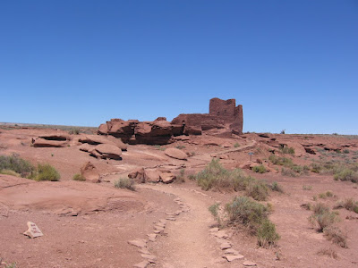
The Wupatki Trail is 0.5 miles and visits the largest Ancestral Ruins site in Wupatki National Monument, near Flagstaff in northeast Arizona. Wupatki is in a unique location on the borders of several cultural traditions in the southwest and is also in one of the warmest and driest climates.

The Wupatki Trail begins at the Visitor Center and starts with a good overview of the site. There is a trail guide here with 20 stops and also interpretive signs in a few places. There are cinders in the area from the eruption of nearby Sunset Crater volcano. Wupatki was settled after the volcano eruption but it isn’t known if these two events are related. It is known that the volcanic ash retains moisture and may have helped with agriculture in an otherwise very dry area. Wupatki may have served as a trade area given its border location. The structure is three stories high in some places.

Like some other large sites in the region, the natural boulders form part of the structure. The stones used as bricks here are long and flat compared to the style used in the area close to Mesa Verde. I didn’t notice any dark basalt stones here as there are some of the other Wupatki National Monument sites.

North of the main structure there is a Great Kiva type structure. The interpretive information says that no evidence for a roof was found here and the typical floor features, like the ventilation system, of other Great Kivas are missing, so this may have been an open air community structure. In the colder climates, I usually think the kivas are best used for cold weather survival. Although it is warmer here than the higher elevation areas, there would still be some snow and cold here, and in the summers the sun would be too intense during most hours of the day without some sort of shade roof.

It does appear that there is a fire pit on the floor here. The bench area here is at a level that makes sitting practical. Sometimes, at other sites sitting on the bench is blocked by the low roof. Toward the end of the trail there is a smaller rectangular room that is described as a kiva.


The most unique structure at Wupatki is the structure that is described as the ball court. Ball courts are common at sites in southern Arizona and it appears to be an idea from cultures in Mexico. The court here is 78 feet wide and 102 feet long with a 6 foot high wall. It is something like a hockey rink.

Next to the ball court is a geologic feature called a blowhole. This is a crevice in the earth surface that appears to breathe based on changes in atmospheric pressure. During my visit the blowhole was inhaling. I set my trail guide over the screened hole and felt it get pulled to the screen as if by a strong exhaust fan.


The return leg of the trail passes an area where Park Rangers lived in the early years of the park. Apparently parts of the ruins were rebuilt, but then disassembled later. One of the rooms on the back side of Wupatki is formed largely from natural boulders and visitors are allowed to enter this room.

The overall site is surrounded by many small dwellings. A few of them can be sighted, but they are off the trail and not accessible. The Visitor Center has several displays of artifacts and interpretation.

Sunday, May 9, 2010

Lava Flow Trail at Sunset Crater

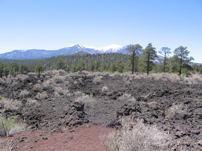
The Lava Flow Trail is a 1.0 mile loop at the foot of Sunset Crater Volcano in Sunset Crater National Monument in northeast Arizona near Flagstaff.


Sunset Crater is the youngest of many cinder cone volcanoes in the north Arizona area. The eruption date for Sunset Crater is between 1040 and 1100 AD. The date was established from the wood in the buried pithouses found under the cinders. The height of the cone is1000 feet and the diameter at the base is one mile. It is 2250 feet from rim to rim.

The ash fall from the eruption extended over 800 square miles. The first part of the trail is a paved loop, while the distant loop passes through a lava flow and cinder barrens. Sunset Crater is closed to climbing to the rim. There is a trail guide here with 13 marked stops plus several interpretive signs.


One of the features of the lava flow is an example of a “squeeze up.” As the lava flows, a thin crust forms on the surface. An increase in flow causes the crust to bulge and crack. The crack continues to widen and the molten lava below squeezes up through the crack.

All of the lava, whether jagged blocks called aa, or ropey surfaced pahoehoe, or cinders is basalt rock. There is a display in the visitor center that says basalt is a low viscosity type of lava and has 48 to 55% silica content.

Another feature pointed out is a spatter cone. These form when lava is forced up through an opening in the cooled surface of a lava flow. The fluid fragments spurt upwards, then congealing and mounding around the opening. The eruption of Sunset Crater is part of the tradition of the people that are descended from those who lived here at the time. The ash spread by the eruption played a role in the agriculture of the villages and pueblos of the nearby Wupatki area.

Lenox Crater Trail

The Lenox Crater Trail is a 1 mile round trip to the top of a volcano cinder cone. This trail is within sight of Sunset Crater in Sunset Crater National Monument in northeast Arizona.

The trail climbs 300 feet, is mostly straight up, and is steep enough and at high elevation to cause most hikers to stop several times to catch your breath. The footing is all cinders. At the top there are views toward the San Francisco Peaks across the shallow depression of the cone. This is an older cinder cone and Ponderosa Pines have established themselves. The views up the trail are mostly blocked by the forest but the pine scent is always refreshing.
There are also some views toward Sunset Crater and the Lava Flow Trail area. Sunset Crater is no longer available for climbing, so Lenox Crater is an opportunity to view into a volcano crater. It looks like the Sunset Crater would be a much tougher climb.

Saturday, May 8, 2010

Wukoki Ruins Trail

The Wukoki Trail is a short 0.2 mile walk to an Ancestral Pueblo ruins site in Wupatki National Monument in northeast Arizona, north of Flagstaff. This trail is on a 2.5 mile spur road that begins near the Visitor Center and the Wupatki Trail.
If you enter Wupatki National Monument from the west entrance, this is the last of the four trails before continuing on to Sunset CraterNational Monument.

Wukoki is the modern Hopi word for “Big House.” The arrangement of sites in the Wupatki area reminds me of the Chaco Canyon area where the large monumental ruins sites are spread out in a dry environment.

Like Chaco Canyon, the Wupatki area appears to have been a center of activity. On the border between Ancestral Pueblo, Sineagua, and Cohonina cultures, a rich variety of pottery and traded goods has been found here.

Thursday, May 6, 2010

Citadel Ruins Trail at Wupatki

The Citadel Trail is a short but steep 0.2 miles to a large ruins structure sitting on a lava capped mesa. This trail is on the western side of Wupatki National Monument, north of Flagstaff in northeast Arizona.


At the base of the volcanic mesa is the Nalikihu Ruins site, the name a Hopi word for “House Outside the Village”. The wall arrangements show that this 800 year old farming site was built in stages and pottery styles similar to the Citadel indicate that both structures were used at the same time.


The Citadel has commanding views of the surrounding Antelope Prairie countryside. On the south side there is a large limestone sink hole and the San Francisco Peaks. The interpretive signs along the trail discuss why the Ancestral Pueblo people chose to build on these elevated locations, and perhaps it is for the excellent views.

The stonework at the Citadel incorporates the volcanic basalt rocks mixed in with the limestone and sandstone that the nearby Lomaki Trail sites use. The foundation for the site is a massive outcrop of the dark basalt volcanic rock.

From the Citadel mesa top there are eight pueblo ruins sites visible along the Earth Crack farming area to the west. Three of these sites are visited by the Lomaki Trail. It appears that at one time this was a large connected community. Farming in this area was affected by the water absorbing ash layer from the eruption of the nearby Sunset Crater. It is thought that this area was abandoned by 1250 AD.

Wednesday, May 5, 2010

Lomaki Ruins Trail

The Lomaki Trail is 0.5 miles to three Ancestral Pueblo ruins sites in Wupatki National Monument in northeast Arizona. Wupatki is north of Flagstaff, AZ along Highway 89. The trail has several interpretive signs along the way.

Two of the ruins sites are called the Box Canyon Ruins, perched on the edge of a feature called an Earth Crack. The Earth Cracks in the Kaibab Limestone were caused by the volcanic activity to the south. This area is called the Antelope Prairie, a dry, windswept grassland. Along the earth crack the soil catches enough moisture to allow farming corn and squash. The building stones here are a mix of sandstone and limestone.


At the distant end of the trail is Lomaki Ruin, positioned at the edge of the earth crack, and spilling down into it. Visitors can walk through and look into some of the rooms.

Looking back to the south there are good views toward the Box Canyon Ruins and the San Francisco Peaks. The stones used in building here appear to longer and flatter than the more loaf style sandstone bricks that seem to dominate the Mesa Verde region to the north and east of here.

There are more ruins sites along this earth crack than the three that the trail visits. At least two more can be seen along the road as visitors arrive at the parking area. This short walk takes about 30 minutes, depending on how long you want to linger.

544544_$20 off any hotel booking of $350 or more with code TLSALE20